

West Slopes Central
Backcountry Avalanche Forecast
Author: Irene Henninger
Issued: Sunday, March 8, 2026 at 6:30 PM PDT
Expires: Monday, March 9, 2026 at 6:30 PM PDT
The Bottom Line
 The Bottom Line
A convergence zone will deposit over a foot of snow Sunday night and Monday in the zone. Strong winds will redistribute snow into thick drifts that will avalanche with a human trigger, and natural avalanches are possible. Shift your travels away from steep, wind-loaded slopes and stick to sheltered or lower-angle terrain.
Avalanche Danger
Monday, March 9, 2026
7500-5500ft3 - Considerable

5500-4500ft3 - Considerable
4500-2500ft2 - Moderate

Tuesday, March 10, 2026
7500-5500ft3 - Considerable
5500-4500ft3 - Considerable
4500-2500ft2 - Moderate
Avalanche Danger ScaleLearn moreGeneral InfoGeneral Information1 - LowLow2 - ModModerate3 - ConsConsiderable4 - HighHigh5 - ExtrExtreme
 1 - Low | 2 - Moderate | 3 - Considerable |  4 - High |  5 - Extreme | |
|---|---|---|---|---|---|
| Travel Advice | Generally safe avalanche conditions. Watch for unstable snow on isolated terrain features. | Heightened avalanche conditions on specific terrain features. Evaluate snow and terrain carefully; identify features of concern. | Dangerous avalanche conditions. Careful snowpack evaluation, cautious route-finding and conservative decision-making essential. | Very dangerous avalanche conditions. Travel in avalanche terrain not recommended. | Extraordinarily dangerous avalanche conditions. Avoid all avalanche terrain. |
| Likelihood of Avalanches | Natural and human-triggered avalanches unlikely. | Natural avalanches unlikely; human-triggered avalanches possible. | Natural avalanches possible; human-triggered avalanches likely. | Natural avalanches likely; human-triggered avalanches very likely. | Natural and human-triggered avalanches certain. |
| Avalanche Size and Distribution | Small avalanches in isolated areas or extreme terrain. | Small avalanches in specific areas; or large avalanches in isolated areas. | Small avalanches in many areas; or large avalanches in specific areas; or very large avalanches in isolated areas. | Large avalanches in many areas; or very large avalanches in specific areas. | Very large avalanches in many areas. |
Avalanche Problems (2)
Problem #1: Wind Slab
Problem Type
Wind Slab
Aspect/Elevation
Likelihood
Size
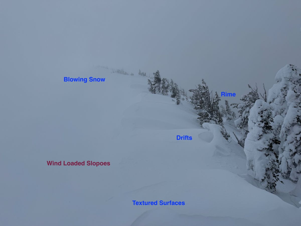
Blowing snow, textured surfaces, rime, and drifts make it easy to locate wind loaded slopes.
Photo: Dallas GlassAvalanche danger will increase throughout the day as more snow falls. Thick drifts will quickly form, and it's likely that they'll avalanche with a human trigger. There could also be natural avalanches as wind and snowfall continues. Expect smaller slabs at lower elevations, and they will increase in size and reactivity as you gain elevation.
Deposits tend to form around rocky outcroppings and other features, in gullies, and on the leeward side of ridges or subridges. Sometimes, only a subtle change in the terrain is enough to build thicker, reactive drifts in one spot, stripping snow from surfaces only a few feet away.
Search for smooth, rounded drifts or textured surfaces to help you identify wind slabs. Look for actively blowing snow and notice where the snow lands. Steer around steep, wind-drifted slopes on Monday. If you encounter bullseye clues like long, shooting cracks, that's a clear warning sign to avoid steep slopes. If there are any natural avalanches, danger may be higher, so shift your travels away from areas beneath large overhead avalanche paths as well.
Problem #2: Wet Slab
Problem Type
Wet Slab
Aspect/Elevation
Likelihood
Size
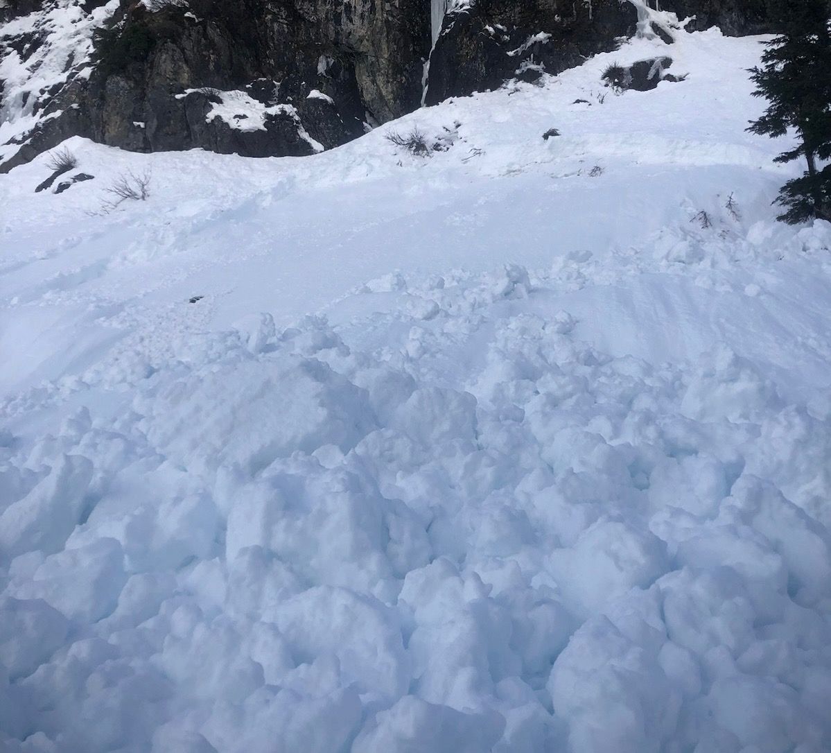
(3/8/2026)
A large wet slab avalanche in the neighboring West North zone that occurred early Sunday morning. This happened at 6am in previously unskied terrain, after a 3-hour period that resulted in over .75" of rain. The slab was reported as having a 30" crown, likely failing on one of our underlying weak layers that are progressively healing.
Photo: Mt Baker Ski Patrol
It took longer for temperatures to cool than expected Saturday night and Sunday. Around two inches of rain fell throughout the zone in this time block, and wet slab avalanches may have released, as they did in our neighboring West North zone.
There could be lingering cornice falls or a glide crack or two opening up as cooling happens. Beware of traveling beneath large overhead hazards like large, saggy cornices, recently wrinkled snow, or newly opened glide cracks. As for wet slabs, it's hard to pinpoint where they may happen. Large, open slopes are where they're most likely to happen, so consider traveling quickly beneath these areas during your outing.
As temperatures drop, we expect weaknesses in deeper, underlying layers to quickly dissipate, but we're keeping this wet snow problem on the table for one more day.
Forecast Discussion
Snowlines shifted lower in elevation during the day on Sunday. We expect that with the slow transition from rain to snow, bonding should be good between the new snow and the underlying wet layer. Given the cold temperatures we'll have on Monday, the new snow will be fairly low density. In non wind-loaded areas, there's a chance that you could still trigger small slab avalanches, although they will probably be harder to trigger. Sluffs, or loose dry avalanches, are more likely to happen if you venture into steep, non wind-loaded terrain.
I was in the north side of the Mtn Loop on Saturday, and found wet, saturated snow to almost 5500ft, and it likely existed much higher than that. Snow was moist all the way down to underlying weak layers, about two feet deep. I didn't find any significant weaknesses at any of the layers, that we've had concerns about for the last week. We suspect they're healing. I saw many rollerballs that had formed mainly Friday night as temperatures rose above freezing, which will likely freeze into hard chunks as temperatures cool.
This information is provided by the U.S.D.A. Forest Service and describes general backcountry avalanche hazard and conditions.
It does not apply to ski areas and highways where avalanche mitigation is conducted.