

West Slopes Central
Backcountry Avalanche Forecast
Author: Lee Lazzara
Issued: Saturday, March 7, 2026 at 6:00 PM PST
Expires: Sunday, March 8, 2026 at 7:00 PM PDT
The Bottom Line
 The Bottom Line
Higher elevations will see stronger west winds capable of drifting snow into fresh slabs. Avoid steep slopes accumulating blowing snow. A shift toward colder temperatures and continued snowfall should bring more wintry conditions back next week.
Avalanche Danger
Sunday, March 8, 2026
7500-5500ft3 - Considerable

5500-4500ft2 - Moderate

4500-2500ft1 - Low

Monday, March 9, 2026
7500-5500ft3 - Considerable
5500-4500ft2 - Moderate
4500-2500ft2 - Moderate
Avalanche Danger ScaleLearn moreGeneral InfoGeneral Information1 - LowLow2 - ModModerate3 - ConsConsiderable4 - HighHigh5 - ExtrExtreme
1 - Low | 2 - Moderate | 3 - Considerable |  4 - High |  5 - Extreme | |
|---|---|---|---|---|---|
| Travel Advice | Generally safe avalanche conditions. Watch for unstable snow on isolated terrain features. | Heightened avalanche conditions on specific terrain features. Evaluate snow and terrain carefully; identify features of concern. | Dangerous avalanche conditions. Careful snowpack evaluation, cautious route-finding and conservative decision-making essential. | Very dangerous avalanche conditions. Travel in avalanche terrain not recommended. | Extraordinarily dangerous avalanche conditions. Avoid all avalanche terrain. |
| Likelihood of Avalanches | Natural and human-triggered avalanches unlikely. | Natural avalanches unlikely; human-triggered avalanches possible. | Natural avalanches possible; human-triggered avalanches likely. | Natural avalanches likely; human-triggered avalanches very likely. | Natural and human-triggered avalanches certain. |
| Avalanche Size and Distribution | Small avalanches in isolated areas or extreme terrain. | Small avalanches in specific areas; or large avalanches in isolated areas. | Small avalanches in many areas; or large avalanches in specific areas; or very large avalanches in isolated areas. | Large avalanches in many areas; or very large avalanches in specific areas. | Very large avalanches in many areas. |
Avalanche Problems (1)
Problem #1: Wind Slab
Problem Type
Wind Slab
Aspect/Elevation
Likelihood
Size
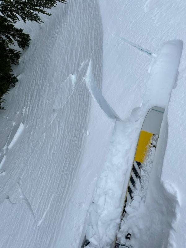
(4/9/2022)
Stiff, slabby snow? Check. Cracking? Check. Wind-affected surface? Congratulations, you found a wind slab!
Photo: Dallas Glass
Modest amounts of new snow in the forecast shouldn’t add much to avalanche danger on their own. Adding wind to the picture is another story. At mid elevations, the only snow available for transport should be what falls after rainfall switches to snow early in the morning. Slabs at those elevations might be reactive, but not very big. At upper elevations, colder temperatures have kept the snow surface drier, allowing it to drift more easily and for wind slabs to grow thicker.
Monitor changes in new snow depth and stiffness as you gain elevation or switch aspects. Test slopes and hand pits can help you gauge the bond of new wind slab layers, but the safest bet is to avoid steep slopes on the receiving end of blowing and drifting snow. An added complication is that a small wind slab avalanche could trigger a larger slab failing on older weak layers buried deeper in the snowpack.
Forecast Discussion
Warm and wet weather has dominated the central Cascades so far this weekend. Rain has fallen through mid elevations in many areas, saturating the upper snowpack and producing scattered wet avalanche activity.
An NWAC forecaster near Darrington found overall wet conditions on Saturday, with no dry snow at the surface up to about 5500 feet. Numerous rollerballs and one wet avalanche, about D2 in size, had released in the past 24 hours, likely overnight when rainfall was heavier and more consistent. Rollerballs and small wet snow avalanches were very stubborn to trigger. About 2 feet of moist snow sits over crusts from late January and early February, but snowpack tests revealed no layers of concern.
Observers near Snoqualmie Pass reported wet avalanche debris near Source Lake flowing out of the Bryant Peak Couloir, and a large glide release occurred at Alpental. Wet snow and poor riding conditions kept backcountry observations to a minimum on Saturday in West North. The few who were out reported the snow surface simply became wetter with light rainfall, but no new wet avalanches or other signs of instability were noted as of late afternoon.
This information is provided by the U.S.D.A. Forest Service and describes general backcountry avalanche hazard and conditions.
It does not apply to ski areas and highways where avalanche mitigation is conducted.