

West Slopes Central
Backcountry Avalanche Forecast
Author: Josh Hirshberg
Issued: Tuesday, March 24, 2026 at 7:18 PM PDT
Expires: Wednesday, March 25, 2026 at 6:30 PM PDT
The Bottom Line
 The Bottom Line
By Wednesday afternoon, you may be able to trigger small avalanches at middle and upper elevations where the wind drifts snow. Use caution on steep slopes with new snow, especially just below ridges. Light snow will fall overnight as temperatures cool with increasing snow and wind by Wednesday afternoon.
Avalanche Danger
Wednesday, March 25, 2026
7500-5500ft2 - Moderate

5500-4500ft2 - Moderate
4500-2500ft1 - Low

Thursday, March 26, 2026
7500-5500ft2 - Moderate
5500-4500ft2 - Moderate
4500-2500ft1 - Low
Avalanche Danger ScaleLearn moreGeneral InfoGeneral Information1 - LowLow2 - ModModerate3 - ConsConsiderable4 - HighHigh5 - ExtrExtreme
1 - Low | 2 - Moderate |  3 - Considerable |  4 - High |  5 - Extreme | |
|---|---|---|---|---|---|
| Travel Advice | Generally safe avalanche conditions. Watch for unstable snow on isolated terrain features. | Heightened avalanche conditions on specific terrain features. Evaluate snow and terrain carefully; identify features of concern. | Dangerous avalanche conditions. Careful snowpack evaluation, cautious route-finding and conservative decision-making essential. | Very dangerous avalanche conditions. Travel in avalanche terrain not recommended. | Extraordinarily dangerous avalanche conditions. Avoid all avalanche terrain. |
| Likelihood of Avalanches | Natural and human-triggered avalanches unlikely. | Natural avalanches unlikely; human-triggered avalanches possible. | Natural avalanches possible; human-triggered avalanches likely. | Natural avalanches likely; human-triggered avalanches very likely. | Natural and human-triggered avalanches certain. |
| Avalanche Size and Distribution | Small avalanches in isolated areas or extreme terrain. | Small avalanches in specific areas; or large avalanches in isolated areas. | Small avalanches in many areas; or large avalanches in specific areas; or very large avalanches in isolated areas. | Large avalanches in many areas; or very large avalanches in specific areas. | Very large avalanches in many areas. |
Avalanche Problems (1)
Problem #1: Wind Slab
Problem Type
Wind Slab
Aspect/Elevation
Likelihood
Size
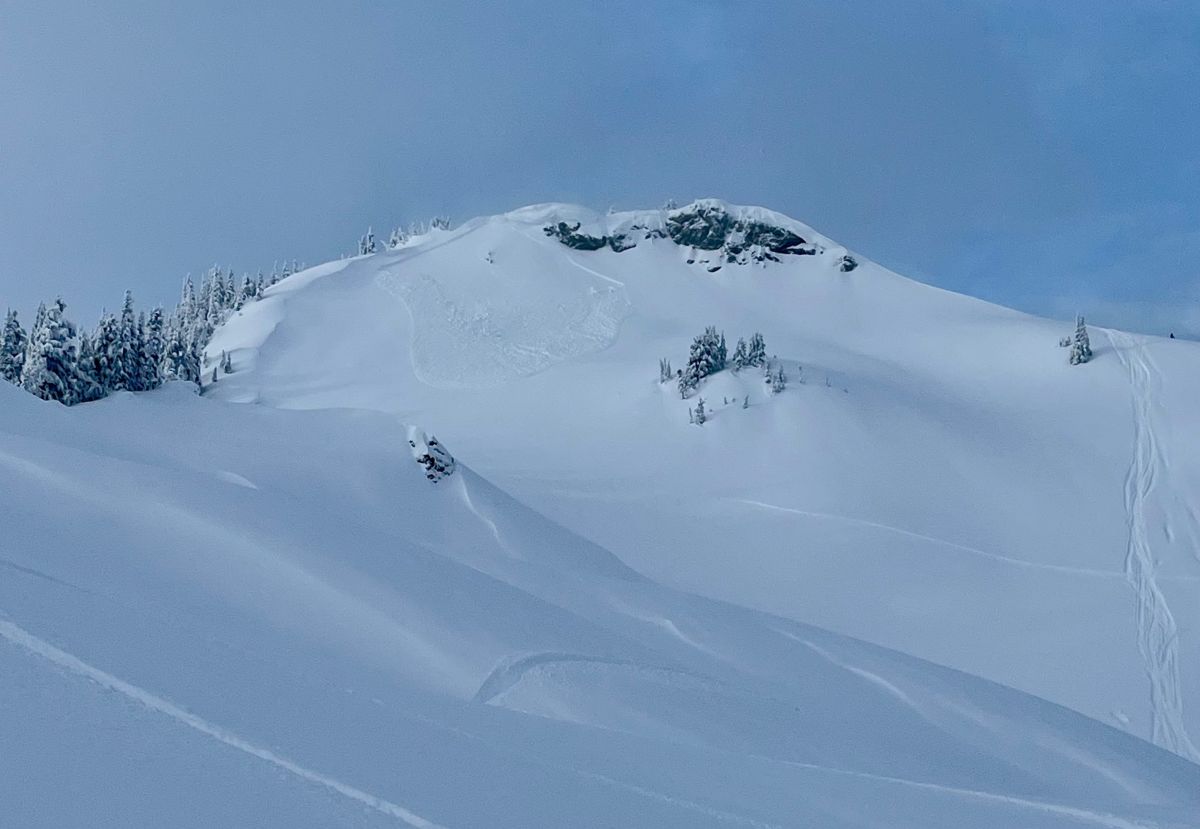
An example of a wind slab avalanche in the Bearpaw area at Canyon Creek.
Photo: Hilary GrohWatch for blowing snow and building drifts to show you where you might be able to trigger a slide. If you find 4" of new snow or more of new snow over a crust, use caution on slopes over 35 degrees. Steer around deeper drifts and steep, convex roll-overs. Use caution where avalanches could push you into rocks, trees, or other terrain traps.
New snow will fall on a moist and refreezing crust. Check the bond between the new and old snow. With forecast new snow amounts upwards of 7", avalanches will be small.
Forecast Discussion
Temperatures will cool on Tuesday night, and the wetted surfaces will begin to freeze. At the same time, precipitation will shift back to snow. The bulk of the snow is expected in the second half of Wednesday. We have uncertainty about the bond of new snow to surfaces that were wetted by over 2" of rain on Tuesday. On Monday, most slopes held a stout 10" crust, but it's to be determined whether any of that frozen layer remains after the rain.
on Monday, NWAC Forecasters along the west slope of the Cascades found Low danger and thick crusts. Temperatures were warmer to the south–a high of 49F at the White Chuck Tripod at 5000 feet in West Central–so snow surfaces actually softened up even on shaded slopes. On the other hand, the mercury only topped out at 38F at the same elevation in West North, and the snow surface generally stayed firm, bumpy, and unforgiving. Stevens Pass may have been the sweet spot with corn-like soft snow conditions found on southeast through southwest aspects. The other big difference is the amount of new snow over the crust: little or none in West Central and Stevens Pass, compared to 2-4 inches farther north.
This information is provided by the U.S.D.A. Forest Service and describes general backcountry avalanche hazard and conditions.
It does not apply to ski areas and highways where avalanche mitigation is conducted.