

West Slopes Central
Backcountry Avalanche Forecast
Author: Lee Lazzara
Issued: Thursday, March 12, 2026 at 6:30 PM PDT
Expires: Friday, March 13, 2026 at 6:30 PM PDT
The Bottom Line
 The Bottom Line
Avalanches are most likely on steep slopes where more than 6 inches of new snow has accumulated or where wind has drifted snow into slabs. The greatest hazard will be in upper-elevation, wind-exposed terrain. Small loose avalanches can be found on steep slopes holding soft, unconsolidated new snow.
Avalanche Danger
Friday, March 13, 2026
7500-5500ft3 - Considerable

5500-4500ft2 - Moderate

4500-2500ft2 - Moderate
Saturday, March 14, 2026
7500-5500ft2 - Moderate
5500-4500ft2 - Moderate
4500-2500ft1 - Low

Avalanche Danger ScaleLearn moreGeneral InfoGeneral Information1 - LowLow2 - ModModerate3 - ConsConsiderable4 - HighHigh5 - ExtrExtreme
1 - Low | 2 - Moderate | 3 - Considerable |  4 - High |  5 - Extreme | |
|---|---|---|---|---|---|
| Travel Advice | Generally safe avalanche conditions. Watch for unstable snow on isolated terrain features. | Heightened avalanche conditions on specific terrain features. Evaluate snow and terrain carefully; identify features of concern. | Dangerous avalanche conditions. Careful snowpack evaluation, cautious route-finding and conservative decision-making essential. | Very dangerous avalanche conditions. Travel in avalanche terrain not recommended. | Extraordinarily dangerous avalanche conditions. Avoid all avalanche terrain. |
| Likelihood of Avalanches | Natural and human-triggered avalanches unlikely. | Natural avalanches unlikely; human-triggered avalanches possible. | Natural avalanches possible; human-triggered avalanches likely. | Natural avalanches likely; human-triggered avalanches very likely. | Natural and human-triggered avalanches certain. |
| Avalanche Size and Distribution | Small avalanches in isolated areas or extreme terrain. | Small avalanches in specific areas; or large avalanches in isolated areas. | Small avalanches in many areas; or large avalanches in specific areas; or very large avalanches in isolated areas. | Large avalanches in many areas; or very large avalanches in specific areas. | Very large avalanches in many areas. |
Avalanche Problems (2)
Problem #1: Storm Slab
Problem Type
Storm Slab
Aspect/Elevation
Likelihood
Size
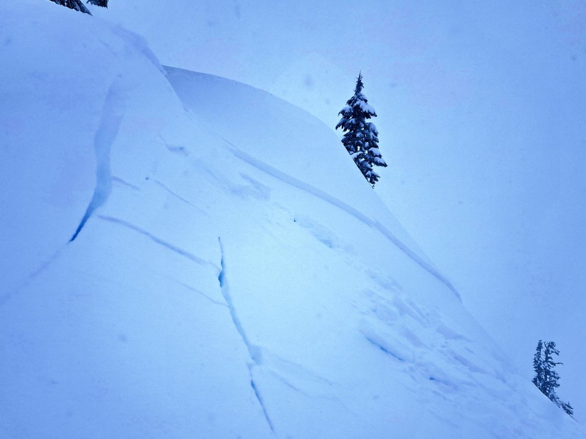
Crown of a large slab triggered from the ridge just above. Slope was actively getting loaded with wind-drifted snow.
(SS-D2-ASr-I)
Photo: Lee LazzaraSlab avalanche danger will primarily be found on wind-loaded slopes, but look for instability anywhere 6 or more inches of new snow has accumulated. Watch for denser snow over softer snow below, especially as the day warms and the surface begins to slab up over colder snow beneath. Moderate winds in alpine terrain may also drift soft new snow into shallow slabs. Older, thicker wind slabs from the last storm are still out there but are likely very stubborn to trigger.
Simple tests can help identify the strength of new snow and wind slab layers. Older wind slabs may be too thick and dense to learn much by digging around with your hand or stomping on small slopes. Use the usual visual clues—such as cornices and wind-drifted features—to identify potentially wind-loaded slopes. Light-density new snow could hide signs of the denser, slabbier snow below.
Problem #2: Dry Loose
Problem Type
Dry Loose
Aspect/Elevation
Likelihood
Size
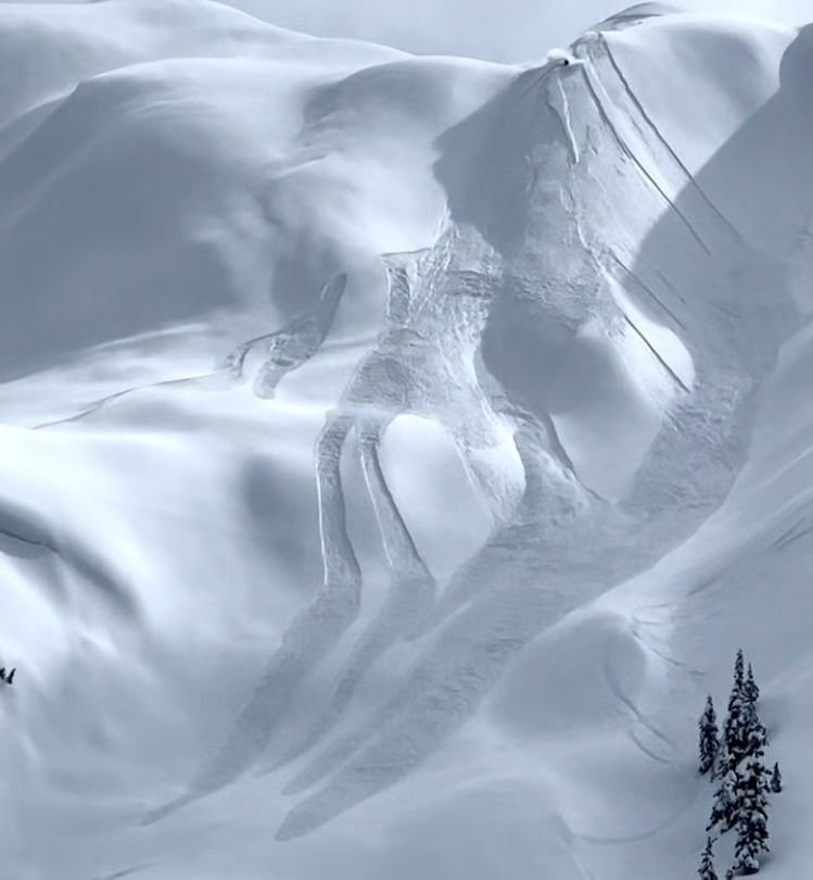
(4/2/2023)
Loose dry avalanches can pack quite a punch in big, fall-line terrain.
Photo: Jason Speer
Anywhere from 4 to 8 inches of low-density new snow will likely lack cohesion and should have a poor bond with crusts or dense wind slab surfaces below. Expect to push some snow downhill with you as you descend or traverse steep slopes. Natural loose dry avalanches are also possible below cliffs and other very steep features. These sluffs are unlikely to bury you, but could push you around or carry you somewhere you don’t want to go.
Forecast Discussion
Observations across have been limited since Wednesday’s storm, making it difficult to get a complete picture of natural avalanche activity. Most of the on-the-ground observations have come from the West North, where numerous filled-in crowns from natural slab avalanches were spotted in wind-exposed terrain. These likely released during the peak of wind and snowfall Wednesday evening. Aside from those, avalanche activity appeared less than expected, and control work on Thursday morning produced no significant results.
A brief warm-up and short period of rain late Wednesday did not appear to destabilize the snowpack in these areas. Instead, warmer temperatures helped the new snow settle and bond, while rain and wet snow left behind a firm surface crust as temperatures quickly dropped.
Elsewhere in the central Cascades, observations remain sparse, but snowfall is more abundant, with over two feet of new snow at Stevens and Snoqualmie Pass over the last few days. Extreme winds on Wednesday night at Snoqualmie Pass shut down several weather stations during the storm. Reports from the area indicate a surface crust formed up to about 3500 feet during the warm period, with new snow accumulating above as temperatures cooled.
Conditions likely vary widely across West Central. Strong winds may have affected some weather station readings, leaving considerable uncertainty about how conditions differ across the zone. One clear takeaway is that wind and snowfall appear to increase the farther south you travel in the Cascades.
This information is provided by the U.S.D.A. Forest Service and describes general backcountry avalanche hazard and conditions.
It does not apply to ski areas and highways where avalanche mitigation is conducted.